
Dates: From September 10th to November 26th, Tuesdays
Time: From 8:30 AM to 12:30 PM.
Workload: 48h.
Registration: R$50, from 8/14 to 9/4, in this link.
Job openings: 200
Location of classes: Auditorium of the Ipiranga Museum.
Presenter: Jorge Pimentel Cintra.
RequirementsGraduates.
A certificate will be provided to participants with 75% attendance.
For more information, click here. here.
The course will present topics from the History of Cartography in Brazil, with practical exercises in map reading.
The classes will be interspersed with an overview of the evolution of cartographic techniques, mainly regarding latitude and longitude measurements, cartographic projections, and prime meridians.
Among the approaches covered in the course will be map reading, paleographic reading of place names, critical analysis of maps as documentary sources and their contrast with other sources; and cross-sectional studies of cartography with science and art.
PROGRAMME
1. Course Presentation. Objectives and approach. The transversality of cartography: literature, history, astronomy, navigation, iconography, mentalities. Mastering cartographic language. Map reading techniques.
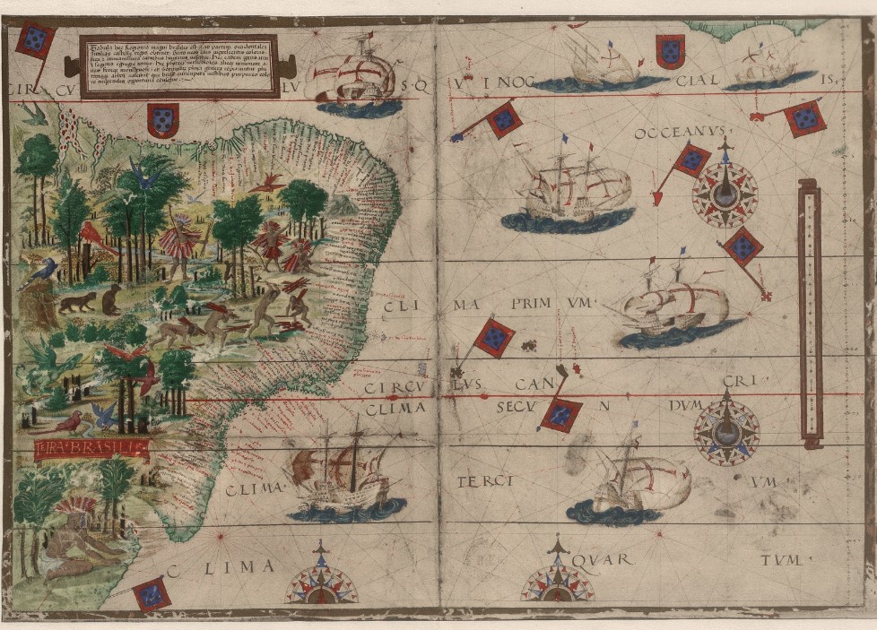
* Map reading exercise: Terra Brasilis, by Pedro Reinel and Lopo Homem.
2. The birth of scientific cartography in the Greek world and an overview of this science in antiquity and the medieval world. The classics in cartography. Ptolemy and his Geography.
* Reading exercise: Ptolemy's world map.
3. Cartography and the Age of Exploration: The Formation of Our Image of the World.
* An exercise in transversality.
4. The development of the concepts of latitude and longitude and the theory of projections, up to the Renaissance. Ptolemy and the conic projection.
* Exercises in analyzing the cartographic quality of historical maps.
5. Master João's Letter and the beginning of cartography in Brazil.
* An exercise in paleographic reading using this letter and sixteenth and seventeenth-century maps.
6. The map as a historical document. Riches and pitfalls. The importance of consulting sources and comparing them with other documents.
* Exercises: the map of the Hereditary Captaincies in Luis Teixeira, in Varnhagen and in textbooks.
7. The history of longitude. Galileo and the moons of Jupiter, Huygens and pendulums, Harris's chronometer. Modern methods: telegraph, radio clock, and GPS.
* Practical exercise: calculating the longitude of the Tordesillas meridian.
8. Prime meridians and map discrepancies. Prime meridians on maps of Brazil: Cape Verde, Ilha do Ferro, Paris, Morro do Castelo, and Greenwich.
* Exercise: the prime meridian of the map Brasilia qua parte paret Belgis, by Jorge Marcgrave
9. History of latitudes in Brazil. Latitudes in 16th and 17th century maps and itineraries; the astrolabe and its use in conjunction with tables of solar declination.
* Exercise: analysis of latitudes in the "Roteiro de todos os sinais" (Route of all signs), by Luis Teixeira.
10. History of longitudes in Brazil. Longitudes on old maps. History of the Map of the Courts and the maps of the Mathematical Priests.
* Exercise: Analysis of the Map of the Courts and its intentional distortions.
11. Toponymy and cartography in sixteenth and seventeenth-century maps.
*Exercise: Reading and comparative table of toponymy on the maps: Terra Brasilis and Luis Teixeira (attached to the Guide to all signs).
12. Digital cartography as a tool for historical cartography. Examples of application.
* Presentation of digital mapping programs and their possibilities.